Ever wonder what SF would look like rendered as an 8-bit video game map? No? Well, clearly some other nerd has. Check it out in it’s 24-color glory at 8-Bit Cities.
I hear that forest patch on the SE corner is a good place to level up.
Ever wonder what SF would look like rendered as an 8-bit video game map? No? Well, clearly some other nerd has. Check it out in it’s 24-color glory at 8-Bit Cities.
I hear that forest patch on the SE corner is a good place to level up.
I stumbled upon this custom radial map of some guy’s favorite burrito joints and their relative distances from his home. From the looks of it, it’s a map of Santa Clara:
Her son Greg, then 29, had recently introduced her to the “My Maps” plotting feature on Google maps. “He suggested that it would [even] allow me to map his favorite burrito joints, and I took him at his word,” says Brown. “I had radial maps in my head; they seem the most primal, symbolic kind of map. And yet–here’s the beauty and elasticity of maps–perfect for burrito joints!” Wondering about those Korean characters at the bottom? They’re a nod to Greg’s wife, who is Korean. The translation: “I love burritos.”
This looks like something we’d see on Burrito Justice; I’m surprised Johnny0 wasn’t consulted. Although in the Mission we’d definitely have to use feet instead of miles.
(via National Geographic)
Telstar Logistics. Laughing Squid. Burrito Justice. Mission Mission. What happens when they join forces? Mission Blog Force 2010! A veritable historical mapgasm ensues.
Laughing Squid and Telstar Logistics recently exposed us to the historical imagery feature in Google Earth. San Francisco’s 1946 layer proved irresistible, especially concerning the old SF Seals baseball stadium, now home to the Potrero Safeway and Office Depot.
As is inevitable amongst map wonks, the Telstar Logistics and Burrito Justice mapping teams started to wonder exactly where in the stores the bases were located. The alignment of the 1947 photomap is a little wobbly in Google Earth (it’s off by 30-100 feet) so we turned to another favored source for greater precision, Sanborn maps overlaid in GE. Behold the diamond of history.
In the world’s first blogging simulcast, you can see the raw base photos of the Telstar Logistics Surveying Unit along with painfully detailed overlay maps by the Burrito Justice Research Department. Telstar Logistics historical analysis will be available on Laughing Squid posthaste.
For some perspective (because that’s how we roll) here’s opening day for the Giants in 1959, their first game against LA. That’s 16th on the top and Bryant on the right.
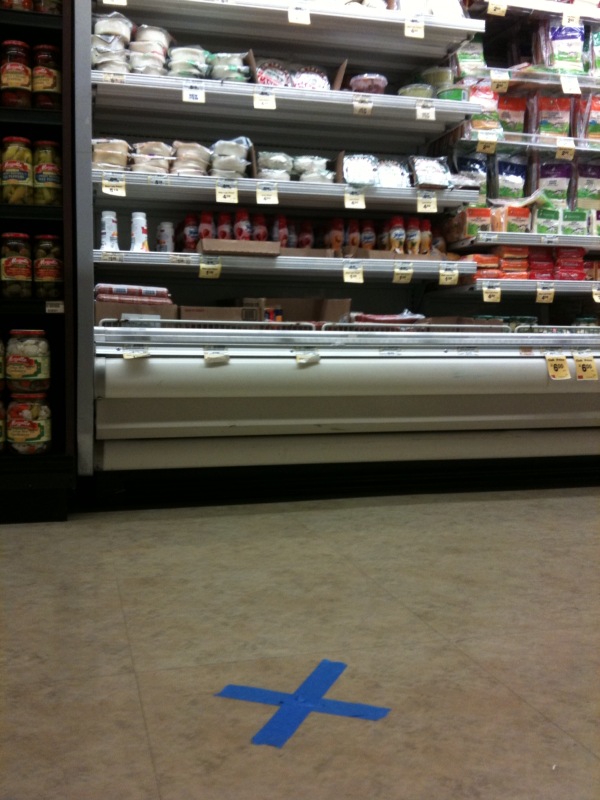
Note that history was made recording history: a blogger ACTUALLY LEFT HIS HOME and went on-site to determine that home plate and 1st are located in Office Depot, while 2nd and 3rd base in Safeway.
Below, blue tape marks third base, looking towards home plate. (Torillas in front of you, and frozen pizzas behind you, as is so often the case when you’re trying to steal home.)

To make this post even more relevant to the Mission — Seals Stadium was also home to the Mission Reds (aka the Missions) before they moved down to Hollywood in 1938.
And prior to Seal Stadium’s construction in 1930, both teams played at 14th and Valencia at Recreation Park. Think of that next time you’re at Four Barrel.

Over at, Lola examines why the web-based tend to tobogan acuatico hinchable skimp on reliable homicide-related info:
The crime map allows you to search for forcible rape, arson, vehicle theft, robbery, burglary, vandalism, aggravated assault, larceny, and drug offenses. But not homicide.
Link to further investigation and conclusions.