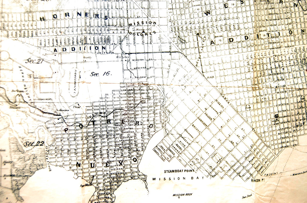
This one comes courtesy of Todd Lappin. Lucky bastard has this beauty hanging on his wall at home (Click on it to see everything in much greater detail). Note that some of us are living in areas that once were called such fanciful things as Beatty Willows, Horner’s Addition, Franconia, and Section 16.
And that the street north of Army was called Navy! How do you like them apples?
Thanks, Todd!

I love this one. Zoomable super hi rez version from Rumsey
.
“Shall we go to the Willows Pleasure Garden and have a beer? Then let us meet at Falcon and Valencia forthwith!”
I clipped and rotated the map from davidrumsey.com to make the street names easier to read. South is up.
[...] Meet you at Valencia and Falcon Mission Mission points us to the most excellent 1861 Langley map of San Francisco, with great detail around the [...]
There is a proposal out there to restore the creek and serpentine routing of Army, ahem, Cesar Chavez. It’s a crazy idea, but it would really be cool. At the very least the section from 101 to Valencia should be re-striped and planted with trees making for a grand entrance to our lovely barrio.
I’d be all over that. I’d heard about the medians through Gillian and Greening Guerrero, but I like re-serpentining better. “That road” really sucks as it is.
While they’re at it, they can run light rail to the 22nd St Caltrain station so my car doesn’t get broken into on Pennsylvania. That station is so close, yet so far.
You can see a bit of the proposed widened, green Cesar Chavez median at Greening Guerrero.
And then you have the light rail over the new grassy median!
I could get behind that.
WHOA. Do I have my numbered streets wrong, or did Dolores Park used to be a… JEWISH CEMETERY?
Yup. It and all of the other cemeteries were moved out of the city soon after the gold rush, mostly down to Colma.
Hey, johnny0, thanks for the plug. The Cesar Chavez Street Design calls for serpentining the median plantings in order to pay homage to the path of the Islais Creek: http://www.sfgov.org/site/uploadedfiles/planning/City_Design_Group/CDG_mission_cesarchavez.htm Hard to serpentine a roadway that carries nearly 40K vehicles per day…gotta do something about that first. Maybe the counts will go down once the PUC rips “That road” up between San Jose Avenue and 101 to install a secondary sewer.
[...] have been diving headfirst into this historical map stuff, helped by several contributors. Check this one out. Amazing. Who knew the Mission had [...]