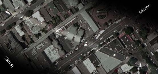
Todd Lappin of Telstar Logistics just turned us onto this: Craig Butz created an amazing site illustrating the route the Southern Pacific Railroad once took through the Mission District. Today the tracks are long gone of course, but there are some lasting remnants in the form of diagonally oriented buildings, parking lots and gardens. Did your backyard used to be a rail yard? Link.
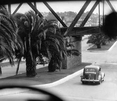
And who knew there used to be a railroad bridge over Dolores Street!?
Thanks, Todd!
Previously on Mission Mission:
From the Mission to Williamsburg, Brooklyn (Thanks to Google Maps Walking Directions)


Best map ever.
Here’s a picture of the 25th and Valencia station in 1906.
http://content.cdlib.org/ark:/13030/hb4q2nb39q/?order=16&brand=calisphere
(Lots of great pictures of our hood on the Calisphere site from the 20s btw, especially Valencia St.)
On the map, notice how wide the path is in some places — the train ran on top of a 20 foot berm through Noe Valley until it came to street level at the Valencia and 25th station. They built the tracks in the 1860s and the city grew around it. There was a trestle bridge across pretty much every street on the way from 30th and Day to the Valencia station, thus the Dolores bridge.
Anyway, it used to be the main line into SF until 1907 when they finished the tracks that Caltrain runs on today through Bayshore. “Our” line dropped to a daily passenger train that ran until 1932. Until 1942 the tracks ran freight and carried coffins from funeral homes in SF down to Colma! Then all the trestles were ripped down and the berms were replaced by houses by the 50s.
But damn, I’d love a Caltrain station at 25th and Valencia, bodies or not.
What’s just as crazy is the cut they had to make for the train to get through the Glen Park hill into Noe Valley in the 1860s. What’s now the San Jose exit from 280 used to be barely wider than the train itself. More pictures here:
http://my.sfgov.org/photogallery/photogallery.aspx?dept=116&search=indexpage&criteria=Saint%20Marys%20Recreation%20Center&cS=2&img=P395&id=1375&page=0&major=&sub=&PoL=&imgNum=1&total=9
http://books.google.com/books?id=Q9tbetmxz0AC&pg=PA61&lpg=PA61&source=web&ots=jR297_sse7&sig=GRuIS1uDpIKjYUbLXzu4VF_I3ig&hl=en&sa=X&oi=book_result&resnum=3&ct=result#PPA63,M1
They widened it in the 30s, and again in the 50s for 280.
I highly recommend the Arcadia Images of America books — they have a bunch on various neighborhoods in SF, some great photos.
Great stuff! Actually this whole thing started because I asked Todd if he had any idea what this infrastructural oddity is. It’s located on the corner of Highland and Mission, due east of the bernal/glen park cut. Any ideas?
Hey Allan. Is that on the northwest corner? There’s a bus with an ad of that annoying/hot e-surance chick blocking it on Google street view…
Almost looks like a vent — since it looks like cast iron, I’m wondering if it has something to do with the city’s high pressure auxilliary water supply system, or for one of the emergency cisterns that are under a lot of intersections.
http://www.sfmuseum.org/quake/awss2.html
There are pictures from that intersection 1922 but unfortunately they face east and north and our I.O. isn’t visible…
http://content.cdlib.org/search?facet=type-tab&relation=calisphere.universityofcalifornia.edu&style=cui&keyword=highland+ave&x=0&y=0
If you have a library card, you can get access to the old Sanborn insurance maps.
This link should work once you’re logged in:
http://sanborn.umi.com.ezproxy.sfpl.org/sanborn/image/download/pdf/ca/reel57/813/00430/San+Francisco+1913-1915+vol.+9%2C+1915%2C+Sheet+904.pdf?CCSI=12747n
If not, browse through to this map:
San Francisco 1913-1915 vol. 9, 1915, Sheet 904
It shows what I *think* is a cistern under that intersection, and something labelled ‘VAC’ on the corner of our I.O. Vacuum maybe?
(Note that particular map is a split view down the diagonal — the left side is to the north of the right side…)
This is all complete guesswork on my part. Maybe someone in the SFFD who’s reading can confirm… Regardless, the Sanborn maps are cool as hell.
-j
[...] More fun with maps: ghost tracks of the Mission [Mission Mission] ?? Bird love on Potrero Hill [The Potrero View] ?? Modernist porn for rich [...]
[...] to believe the SF+SJ railroad trestle bridge used to cross Dolores [...]
[...] (yet again!) to Mission Mission for the heads up on this a wonderful online display showing where the Southern Pacific Railroad [...]